I recently bid on land, and to make the bid competitive, I wanted as few conditions as possible. Normally I would do a perc test and a survey at least, but I wanted to know: could I do enough research on my own to skip these steps and still have confidence I’ll be able to live on the land in a good way (perc test) and that I’m buying what I think I’m buying (survey).
I did this research and felt confident enough to skip both perc test and survey. These are my notes on how I did that and what I discovered.Perc test
“Perc test” is short for percolation test, and it’s a test to see if the soil percolates. If so, you can put a septic system in to handle a building’s human wastes (poop, etc). If not, no go - and you can’t legally live on the land. Normally they’re $300-400 and take a few weeks to schedule.DIY Perc Testing
You can look up DIY perc tests online and find videos of people digging holes with shovels, filling the holes with water (sometimes multiple fills) and timing the drain rate. I didn’t do this, though.With a Little Help From My Friends
I did send out a request to friends, my real estate agent’s contacts, and a community listserv asking for people with experience doing perc tests to give their opinion as to whether I could safely skip the perc test in my case. I gave them all the info I had about the lay of the land, water, geology, and soil (see below about soil). I heard from landowners, people who do perc tests professionally, and people in real estate who deal with perc tests a lot, and all of them said I shouldn’t feel concerned, and the land would perc.Soil Survey Research
I found a county soil map here. It just shows normal parcel boundaries by default, but to see soil data go to the right column, look under “layers” then “images” and click the checkbox next to Soils. I could see exactly what sorts of soils exist on different parts of the land. Then I looked them up in this free soil survey document here. The soil types on the land where I’d consider building are PuE—Porters-Unaka complex, TwD—Toecane-Tusquitee complex, and TwE—Toecane-Tusquitee complex. Each of these is separately described as “well drained” soil, meaning they should perc and accept a septic system.
Of course someday I’ll need to do a perc test to get a septic permit. Given all this, I feel confident I’ll be able to build as I wish.
Doing My Own Survey
A survey of this land would have cost $7k-$8k and taken ~3 months according to my agent. A little background about surveys: the county map showing parcel outlines is convenient to use, but the document that has legal weight is the deed description of the boundaries, and if the county map and deed disagree, the deed wins.
- Deed Research: The surveyor studies the deed’s boundary descriptions as well as the boundary descriptions of all neighboring deeds. The surveyor tries to resolve any ambiguities or disagreements and decide exactly where the lines are.
- Walk the Land: This is the surveying work we’re used to seeing, where surveyors walk the boundary and flag each point along the way.
My deed research
I started by accessing the deed for the parcel I wanted to buy. To access a deed in Yancey County, NC, you go here. Access the parcel you want the deed for by searching by PIN or whatever. Then on the right click ‘Deed Link’ and voila! Here’s the deed for the land I’m buying.
Here’s the boundary the county map shows:
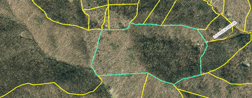
I went through phrase by phrase in the deed boundary description, and after mapping each phrase to one or more lines, I got this map:
The shaded part is not legally part of the land I wanted to buy! Instead, it belongs to the parcel to the southwest of the land I'm buying.

I was bummed, ‘cause the national forest was supposed to border my land to the west. If my deed didn’t include that western part, which other parcel did? And was I definitely reading my deed boundaries correctly?
Ultimately, I found 3 deeds that confirmed my interpretation as well as a survey for the national forest land to the west. This is the research I presented to the sellers:
The text of three deeds shows that the county gis map for the seller’s parcel (pin 987300506546000) is incorrect and that it does not border the national forest.
From seller’s parcel’s deed:
The deed describes a line going, “Southeast 23 poles to a Chestnut Oak on top of a ridge in W.T. Williams’ line” which describes the boundary to the southeast of the parcel. From there, “thence up said ridge with its main height to the BEGINNING”. The BEGINNING is Bob’s knob, showing the parcel’s true boundaries are the ridge on the south and west, not the forest service line to the west of the ridge.
From parcel with pin 987300417371000, to the northwest of seller’s parcel in the county gis map, with deed here:
“...thence S 3 23 11 W 11.84 feet to an existing iron pin on a ridge, the same being a corner with Baity and in the Northern line of lands of Glenn Wilson described at Deed Book 145, Page 119; then with the northern line of the Wilson property...” The County map shows that this parcel connects with seller’s land, not Glenn Wilson’s. However, the deed references a border with Glenn Wilson’s land.
From Glenn and Phyllis Wilson’s parcel pin 987200388568000, with this deed:
“...thence with Burgess McCurry’s line to the top of Bob’s know...” (probably a misspelling of “Bob’s knob”). This shows Glenn and Phyllis’s land extends to Bob’s Knob. This was confirmed by a call with Glenn Wilson on 6/30/2021.
After sending this research to my real estate agent, she pulled some strings and got a survey to the national forest land to the west and this also confirmed my research.
To Buy or Not To Buy
I felt so sad when I discovered this! I really wanted the land to border the national forest! But I thought about it some more, and I realized a few things…- Entrance to the national forest nearby: There’s an entrance to the national forest a mile’s walk/bike/drive down a dead end road.
- Correct acreage: The county map shows an area of about 54 acres. So the seller’s map is incorrect, but the sellers described the parcel as being 36 acres, and the deed says, “35 acres, more or less”, so the acreage was about as I expected.
- The boundaries I wanted: I was specifically looking for land where the boundaries are ridges on 3 sides. The deed very clearly says the parcel boundaries are ridges on the north, west, and south.
Given that acreage was as expected, and the most valuable part of the land is indeed described in the deed correctly, I decided to continue with the bid, and we’re now under contract. On my second bid, the seller’s agent told my agent that I came in at the perfect price - the sellers would not have accepted less. And my no-conditions offer was compelling for them, as they received a verbal offer at the same time that would be contingent on a survey - one they knew would yield a nasty surprise for the buyer, as I’d already sent them my deed research! And so the sellers accepted my bid.
I feel 100% confident in my survey/deed research. And I won’t be 100% confident in my perc test research till I get a perc test someday, but for the time being I feel very secure in proceeding with the purchase. It’s been a very long hunt, and I’m very excited to move onto this land!